Tuesday, December 14, 2010

Haast, NZ: The West Coast Hustle

Lingering on the West Coast seemed to us like living on borrowed time.  Rain was inevitable, just like the rising of the sun and moon each day. When the rain finally eased in Fox Glacier, and the forecast was for a couple of fine days, we saw it as an opportunity to finish off this side of the island.

We crossed rivers swollen from the recent rainstorms.  The peaks shyly appeared as the clouds moved about.

We started our cycling day in a strong drizzle that evolved into something resembling rain. But soon it ended, the clouds parted, and blue skies and a favorable wind greeted us when we emerged from the forested inland to the coastline.

Strong storms have piled driftwood on the sand at Bruce Bay.

We were both "on" this day -- and early start, a slight downhill, and wind in our favor had us at 60 kilometers by lunchtime. And the prospect of smoked salmon may also had some influence. Out here, in this stretch of 100 kilometers between services, is a salmon farm, where wonderful things with pink fish are made. And there was a cafe, and we celebrated my birthday eve with a lunch of great density. Ordinarily, high-fat foods are verboten for me. But when asked what to have on my smoked salmon panini, avocado and cheese were chosen to feed that deep hunger that distance cycling brings on.

Ponds at South Westland Salmon Farm near Lake Paringa.
Full bellies and a couple cups of strong New Zealand brewed coffee pushed us over our normal, comfortable 80 kilometer day. A series of steep, curving roads to get over the coastal headlands didn't even seem to slow us down.

View from Knight's Point lookout.  There were no roads to this coastline when it was settled in the 19th century, and cattle were brought in by boat and had to swim ashore, not far from this location.


The final stretch into Haast -- flat road and deep forest on the edge of the coast.
We pulled into the village of Haast by 6:00 pm, 125 kilometers from where we started that day.  A personal record for both of us for distance with fully loaded panniers. 

But the challenge was not over, since it was another day of cycling to get over Haast Pass to get off the Westland side to the rain shadow of the Otago side.  Not a far distance, but a 564 meter ascent from near sea level. No rest for the weary, or for a girl on her birthday.

The day was brilliant from the start -- blue skies, gentle breezes.  And the road was a moderate grade with gentle curves as it headed towards the pass.  A three kilometer stretch of thigh-busting road after the Gates of Haast made me long to be in my forties again, like I was just the day before.  But all good things come to those who persevere, and it was a thrill to reach the pass and the mid-century mark on the same day.

The Haast River meandering its way to the sea.

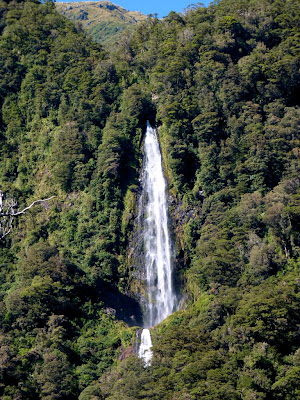
Spectacular waterfalls still flowed from the recent rains.,

The canyon narrows and the peaks get higher as we work our way towards Haast Pass.

The Gates of Haast, the gorge where the Haast River flows down the steepest gradient along its path. 

The birthday girl chugging up the grade.

The Haast River, almost a creek near its headwaters.

Happy Birthday!

Sunday, December 12, 2010

Franz Joseph and Fox Glacier, NZ: Glacier Experiences

Legendary tales have been told to us of the rainfall and sandflies of the West Coast.  We felt lucky to have made it the village of Franz Joseph with a minimal exposure to either.  It has been said, that if the West Coast goes without rain for two days it is considered a drought.  Well it had been at least two to three weeks of fine weather, and the local rural communities were on the verge of imposing water usage restrictions.

So we arrived in Franz Joseph, a tourist mecca for all things related to glacier viewing -- helicopters, sky-diving, ice climbing.  We got there by noon, set up our tent on a sliver of Astroturf behind a hostel, just before it began to come down.  And it rained all afternoon and most of the night and then even some the next morning.  Drought over.

So when the heavens cleared in the afternoon, we ventured out for the eight kilometer walk from the village to the base of the Franz Joseph Glacier.

A muddy torrent of water from the outwash of the Franz Joseph Glacier.

The trail goes over a rise, opening up to the first grand view of the glacier.

Side canyons and cascades were still flowing from the recent deluge.

One can join a guided tour and a princely sum to get closer to or climb the glacier.  But those of us taking the free option can get within 100 meters, which is quite spectacular enough.

Warnings are posted everywhere -- in the parking lot, in the restrooms, and here at the end of the trail -- warning of the hazards of venturing any further.  But apparently budget constraints allow only a cardboard ranger to be present for enforcement.

Blue ice.

Looking downstream of the glacier to the outwash plain.

The sun peeking out at our last glimpse of the Franz Joseph glacier.

As we sat in the warm and dry surroundings of the hostel, we checked the weather frequently hourly obsessively to see when we would get a break. And on the third day the window opened up and we cycled the 25 kilometers over the divide between Franz Joseph and Fox Glacier.  The road between the villages climbs steeply and drops again three times as it goes transverse to alternating ridges and river valleys.

Clouds cling to the peaks after a morning shower.

The plains below Fox Glacier are visible from the final high point on the road.

We quickly made camp and stowed our gear and rode our bikes to the car park of the access trail to Fox Glacier, 6 kilometers away. Only to find the trail to the base of the glacier was closed due to flooding. Great disappointment was soon replaced by bold anarchy, as we crossed the rope lines with a fellow bike tourist from Spain and a 70-year-old Asian man to bypass the flooding and get to the viewpoint anyways.  No arrests by cardboard rangers were made.

The access trail can be seen partially covered by flood waters.

The root of the Fox Glacier seen from our forbidden viewpoint.

Ice floating in flood waters emanating from the base of the glacier.

.

Thursday, December 9, 2010

Westport to Hari Hari, NZ: Along the Road on the West Coast

Images from the journey down the West Coast of the South Island...

Our lunch spot after a steady 10 kilometer climb and a thrilling downhill that brought us to sea level.

Overcast skies, but a classic view nonetheless.

Caverns found along the way, just outside of Punakaiki.

Thin-layered limestone known as Pancake Rocks, near Panakaiki.

The sun came out for five minutes at Pancake Rocks.  We didn't see it again for the rest of the day.

Terns nest on the rock pillars at Pancake rocks.

We were warned about this dangerous, bike-eating bridge south of Greymouth.

And appropriately so -- a one-lane bridge that shares space with a railway track.  A model of Kiwi efficiency.

We didn't ask if they were selling the two- or four-legged variety.  But we did purchase some very excellent goat cheese to fuel us further down the road.

Black sand beach at Hokitika.

The best cycling is through the bush of the national parks and reserves -- like going through a tunnel of green.

As we near Hari Hari, the road bends way inland to find a narrow and stable spot to construct a bridge.  Fine glacial dust colors this river turquoise, giving us a clue of the ice masses in the Southern Alps upstream that are shrouded in clouds.

Dinner preparation at our stealth camp south of Hari Hari.

.

Saturday, December 4, 2010

Buller Gorge, NZ: Pathway to the West

I can't ever recall if I ever traveled along the entire length of a river, from its headwaters to where it empties to the ocean.  But now we can say we have.  The Buller River begins where it spills out from Lake Rotoiti in the Nelson Lakes National Park.  It continues for 170 kilometers to the seaside town of Westport.  And the best part of biking along Highway 6, which parallels the river, is it was all downhill.

The beautiful stillness of morning, downstream of Murchison.

Multiple bridges cross both the main Buller River and its tributaries.  Many are one lane bridges, and bicyclists are well accommodated on the longer ones.

John cycling in the shadow of Hawks Crag, like so many travelers before him.

As we approach the coast, clouds wrap themselves over the ridges.

Flowing, flowing, to the sea.

.

Wednesday, December 1, 2010

Nelson Lakes National Park, NZ: A Photo Album

It was a hot ride from the agricultural wonderland of the Nelson area to the mountain town of St Arnaud. It was a Sunday morning, our most favorite day to ride -- no logging or milk trucks passing us on the road. But as morning turned to afternoon, it heated up to the high 90's. At the end of a particularly steep three kilometer-long hill, we were both so overheated we stood under the shade of a tree for a good half hour and let the breeze bring us down to normal operating temperature, taking off as many articles of clothing within decency.

St Arnaud is at the shore of the glacial-carved Lake Rotoiti, a tiny town with a population of 60, and we were told 30 of those are children.  With just enough services for those seeking to explore the lake and surrounding high country by boat, ski, or foot -- a couple of backpacker hostels, gas staion, and over-priced groceries.  I swear this is the last time I will pay $2.00 for a tiny container of yogurt.

For us, we were keen on doing a three day, two night loop through the Nelson Lakes National Park.  So it required another changeover from biking to hiking gear.  Unfortunately, we did not have a kind local resident to house our bikes for us, so we committed to staying at one of the hostels when we returned from the hike in exchange for gear storage while on our tramp.

Gear preparation in the patio area of the Sabine-Travers Lodge.

A calm morning on the south shore of Lake Rotoiti.
Beech forest surrounds the lake, and our first day of hiking was a short jaunt to the north end of the lake under the canopy of the forest that shielded us from the hot sun.  Compared to the international expressway of the Great Walks we have done so far, this region is less of a "must-do", so it was a peaceful if not solitary experience.
Path through the forest composed of a variety of beech trees -- red, black ,silver, and mountain beech.
And the existence of honeydew has been revealed to us. The beech scale, an insect that bores into the beech tree and consumes the sap, excretes a sweet substance that is important to the ecology of the forest as a food source for many animals.  Black mold growing on the bark of the beech trees are also fueled by this sweet nectar, making the trees look as if they have been singed by fire.

Honeydew droplets at the end of thread-like filaments.
Our second day began to climb out of the forest to above treeline.  We hiked up a canyon carved by the swiftly-flowing Hukere stream.  As the canyon narrowed, the walls around us became steeper, and many downed trees due to windfall and avalanches required crawling on all fours to get by. 

Water cascades from some source high above the canyon.

We finally get above treeline, with a clear view of the ridge that still needed to be scaled before us.

Bridges often seem to be in places where they are most needed.

After about five hours of upward progress we faced a final push over essentially a goat track over scree.  Good thing my husband has the patience of a saint, since I was an unhappy and fatigued tramper at this point.

View looking down to where we began, with still some uphill to go.

Mountain Buttercup
Once over the ridge, we were within spitting range of Angelus Hut, our destination.  A long-time hut location, the actual building was totally rebuilt in the past year.  A stunning setting.

The only location better than the hut was where we set up our tent.
The hut is open to all year, and a wood-burning stove with racks to dry clothes must be especially appreciated for winter ski tourers.
This tramp was a loop, and our return was along Roberts Ridge Route back down to the shore of Lake Rotoiti.

Before we could descend, we had to climb out of the lake basin where Angelus Hut is located.

An alpine plant called appropriately Vegetable Sheep.

The route goes across a bit before it goes down.

Distant peaks and tarn viewed from the ridge.

A rocky section seemingly devoid of plants.

As we drop the ridge becomes more rounded and covered with tussock.


It seemed like most of the elevation was lost in the last couple of kilometers, as the trail wiggled down the scar of a landslide back to our starting point at Lake Rotoiti.

Translate

Copyright

All original text and photos are copyrighted Doris Reilly © 2006-2023. No part of the content or the blog may be reproduced without prior written permission.
Powered by Blogger.

Contact Form

Name

Email *

Message *