Sunday, October 31, 2010

Rotorua, NZ: Into the Volcanic Zone

We found ourselves on gravel road  for a rough 20 km out of Putaruru.  Not that we weren't warned.  A gent at the holiday park said it was a forest road, do not take it, we might get lost.  But we were looking for an alternate route to the busy main highway and to avoid backtracking an extra 5 km.  Our map showed that it was unpaved for only a short stretch, but we reached the gravel very early, after we already had invested 10 km of steep uphill. Where there was a sign that said unmaintained, enter at your own risk. But we went for it anyway.  The quiet around us was lovely as we pushed our bikes up the steep, loose grades, calming us a bit from concern about bouncing panniers.  We passed through a forest, second or third or fourth generation trees that have displaced native vegetation as a crop for timber harvesting.
Notice the orderly rows of trees in the distance.
Our goal was Rotorua, on the edge of a lake formed in the caldera of a volcano.  This town is in the northern section of the area known as the Taupo Volcanic Zone.  We came to explore the steaming landscape of geysers and hot pools.  We stashed our bikes for a day and became indistinguishable from the other tourists.

We spent a good part of the day exploring the Whakarewarewa Thermal Village.  We arrived to view thermal features, but it was more a cultural lesson of the life of this particular Maori tribe. 

Our Maori guide at taking  ten minutes to teach us how to pronounce the name of her village.
The people of this village have lived directly adjacent to the hot pools for generations.  It has been a tradition for them to conduct tours and entertain visitors with traditional Maori dances and song.  It is not a large area, but we were led along the roads of the village where we learned of the lifestyle they are struggling to maintain.

The house on the other side  of the pool is 100 years old, but had to be recently vacated due to shifting of the geothermal hot spots.

Rotorua is a holiday destination, and outside the gates of this village preserved in time is motel after motel offering spas and thermal pools, all tapping into the geothermal resource.  There are also large geothermal plants south of here supplying electricity.  All of these have altered the area so that where there used to be many active geysers, there is now only one. 

Retrieving corn steamed in a muslin bag the hot pool.
None of the homes in the village have kitchens -- all cooking is done in hot pools and boxes built into the ground to steam and roast vegetables, seafood, and meat.  The 60 residents participate in communal bathing each morning and evening (when the tourists are not there, needless to say).

The Pohutu Geyser, actually located on the adjacent, more commercial Te Puia area.
Village children are allowed to dive for coins tossed by visitors from the bridge leading into the village on weekends and holidays.  Despite hot pools all around, this creek is cold.

We walked along the shore of Lake Rotorua in the evening.  Water quality has been degraded by runoff from pastures and sewage discharge, but improvements have been made in recent years.

Rotorua Museum of Art and History
The indigenous Tuhourangi Ngati Wahiao people have lived amongst the steam for hundreds of years.  In 1908 the government funded construction of a spa and resort to attract tourism to the area, and the historic spa house now houses the Rotorua Museum of Art and History.  The contrast between these cultures, each drawn by steaming hot water, just like us, was striking.

.

Saturday, October 30, 2010

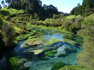
Putaruru, NZ: A Most Beautiful Thing

It wasn't on any of our maps or described in our guidebook.  We only learned of it from the clerk at the motel/holiday park, when we asked if a particular road went through to our destination.

She said if we went that way, we should stop at the spring.  The Blue Spring.  


I asked if it was a warm spring.  Her eyes widened, and she said, oh no, it is deep and cold.


There wasn't even a sign on the road.  We have since learned that 60 percent of the bottled water in New Zealand comes from this source.


Water flowing from the ground never ceases to amaze me.

.

Wednesday, October 27, 2010

The Sleep Spot Project -- New Zealand

When we are on a bike tour, the most important concerns are:  where to go and how to get there, where to buy food and get water, and where to sleep.

If you take a look at the sidebbar to the right, you will see a gallery of our sleep spots -- the level ground where we decided to pitch our tent.

The goal is to capture each night's resting site...check back for periodic updates.  And let me know what you think...

.

Coromandel Pennisula, NZ: A Photo Album

The road on the west side of the peninsula is flat and hugs the shore.
But to cross over to the east side requires climbing several steep, curvy, quad-busting hills.  We can't say we weren't warned -- the fisherman we talked to at Tapapakanga told us to look across the Firth of Thames at night to see the lights of the cars winding up the grades.
The grade heading east out of Coromandel Town was the third and steepest, but offered spectacular views all around.
Any land not under reserve is occupied by bovines or sheep.
The east side of the peninsula has white sandy beaches, azure waters, and plenty of tourists on the Labour Day weekend that we were there.
Cathedral Cove is a beautiful little beach.  The sunbathers are oblivious to the welded tuff above them.
Cathedral Cove has a waterfall, too.  I am not sure if the people who rinsed themselves under the flow realized that it drains from the pasture lands above.
How to steam a Kiwi -- dig a hole at low tide on Hot Water Beach and sit 'em in it.
A good way to poach a Yank, too.
Our first walk through a kauri tree forest.

We rode a stretch of the old railway bed along the Ohinemuri River through the Karangahake Gorge.

The rail bed passed through a 1 km tunnel, intermittently lit by lamps.  It was a bit difficult to see initially, until I realized I had my sunglasses on.  After exiting the tunnel, we had a short downhill and the Coromandel Peninsula was behind us.

Wednesday, October 20, 2010

Tapapakanga Regional Park, NZ: Picture Perfect

Auckland is the biggest city in New Zealand, and it took us all morning to go from city to suburbs to countryside. Traffic was challenging, but Kiwi drivers are courteous and give us plenty of space. We haven't been honked at yet. We only had to call out to each other to stay on the left side of the road a couple of times.

The most disconcerting thing is riding along and hearing an approaching car, looking up, and having a slight adrenaline rush seeing it coming on the right. For that brief moment the mind thinks you are also on the right side and that you will in moments be playing “chicken” with oncoming traffic. Logic soon overcomes the reflexive response, until the next car comes from behind, and then you realize at the last minute it is on your side, and if it is a big truck you will be pulled into its vortex, and the adrenaline spike happens all over again.
Tarmac cutting though green countryside.
This first day out was cold and windy and threatening rain all day. Afternoon was lots of hills, and we pulled into the parking lot of Tapapakanaga Regional Park late in the afternoon. A local fisherman said the campground was closed until the next weekend, but the Park Ranger pulled in shortly and gave us permission to stay. He obviously took pity on a couple of shivering, jet-lagged Yanks.
Our coastal campsite.
We camped in a field of grass with an ocean view. The only sound all night was surf lapping on the beach. Welcome to New Zealand. 

A less than subtle hint of how to frame the photo.

Tuesday, October 19, 2010

Auckland, NZ: City of Sails

So it is time to bring this blog back to life. A full cycle of equinox events have passed since the last post, but our panniers have once again been packed and the bikes boxed. This is the year we have opted for skipping a Sierra winter for travel in New Zealand.

The journey began on October 16 from San Francisco. My Wonderful Sister and Equally Great Brother-in-Law once again allowed us to park our car in their garage for the duration of our five-month trip, and delivered us and our boxes to the airport. Rolling our cargo into check-in, the clerk said the flight was overbooked, and if we might consider volunteering to take the same flight the next day. They would put us up in a hotel, and give us $800 (each!!). John hesitated, and looked at me. He must have seen the dollar signs come up in my eyes when I blinked. So we said, sure, why not?

John and bikes in the Air New Zealand queue.
We were told to go through security and wait at the Evergreen Lounge for Air New Zealand travelers. We would be on standby, and if they needed us to take the flight the next day, they would find us there. So for the next three hours we rubbed elbows with the Executive Class passengers, sat in cushy leather chairs, drank Heineken beer, munched on curry chicken, surfed the Internet, and made plans for what we would do with a free day in San Francisco. We were almost convinced we would be bumped, and heck, if we got bumped on the way home, too, we would make money on this trip!

So we waited. People started to leave when first boarding was called. Pretty soon we were the last ones in the Lounge. And finally the receptionist said we better get going...they did not need us for standby after all. Flip-flop, back to Plan A.

There is not much to say about a 13 hour plane ride, other than sleep is rough and you feel like a pretzel when you finally get off. But I watched three movies on my own personal screen, which is a big fix for this popular culture-deprived soul.

It was just past 6:30 am upon arrival in Auckland, and the airport was just waking up. John found the designated Bike Assembly Area, complete with a rack, where he spent a couple of hours putting the our pieces back together. Conveniently located next to the smoking area and the McDonalds exhaust vent. Rain showers came and went outside, but the statue of Jean Batten seemed to indicate when it was time to go.

New Zealand's way of saying "Welcome Cyclists".

A rainbow signals clearing skies.
We cycled across town to a campground located almost in city center. And the next day we took care of business – buying camping fuel, finding an ATM for cash, and getting a  Telecom T-Stick for Internet access. It took almost three hours to get the stick working on our Ubuntu-powered netbook, but after a bit of hacking we were successful. After a big lunch at the Asian Food Mall, we pedaled around the bay for some nice views of expensive houses perched on cliffs and the city in the distance.

The skyline of Auckland's city center -- the Sky Tower is the most prominent feature and the tallest structure in the southern Hemisphere.
The New Zealand journey has begun, and this blog is once again alive!

Translate

Copyright

All original text and photos are copyrighted Doris Reilly © 2006-2023. No part of the content or the blog may be reproduced without prior written permission.
Powered by Blogger.

Contact Form

Name

Email *

Message *