Friday, May 25, 2018

Plitvicka Jezera National Park, Croatia: Conga Line in the Garden of Eden

It is a mixed blessing to wake up to clouds in the morning. On the positive side, it means that when grinding up a long grade, at least the sweat doesn't wash all the sunscreen off your face and into your eyes.  But it also means, when you get to the top of whatever you invested all that energy into, the view might be less than spectacular.  So it was when we left our waterfall camp at Knin and continued our journey through the Croatia hinterlands.


A wide valley view north of Knin under a canopy of clouds.  We anticipated rain all day, but fortunately we found refuge when a few drops fell at lunchtime.  We ducked into an empty service building at a cemetery, which was fine.  But the groundskeeper decided to light all the piles of dry grass accumulated from the last weed-whacker session, and it smoked us back onto the road rather quickly.

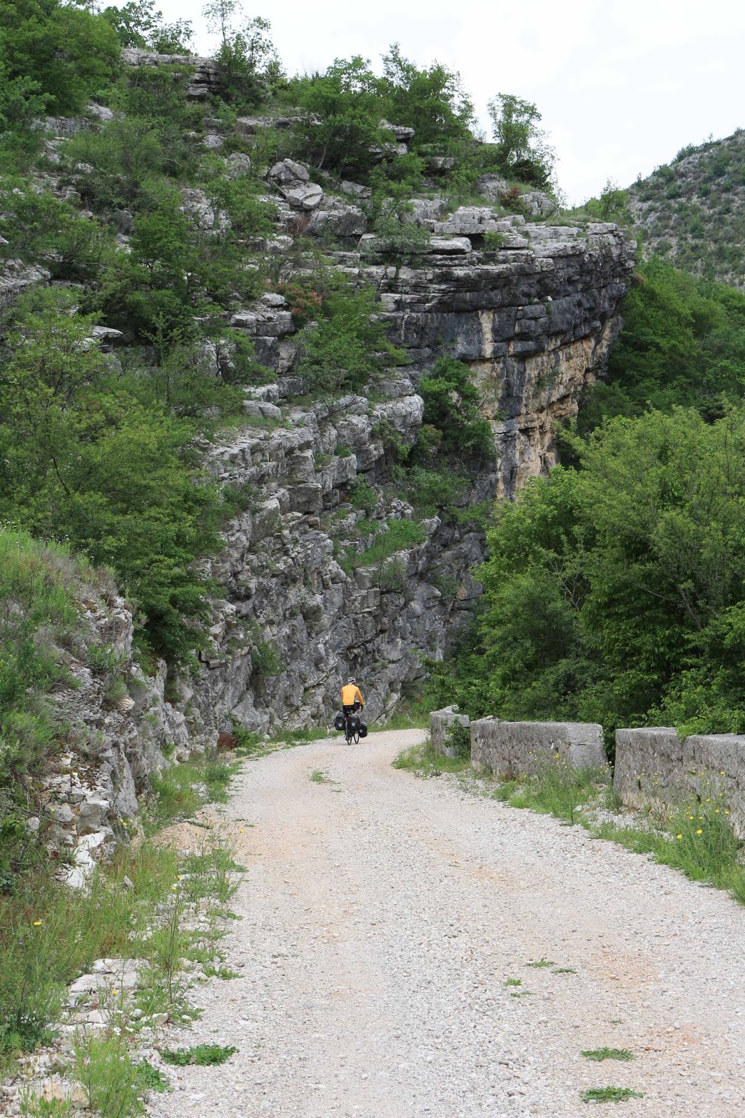
We found the best stealth campsite yet on the trip in an abandoned pasture in an oak forest.  And the sun came out for a couple of hours before dropping below the horizon.  But morning was a different story.  We managed to eat breakfast and pack the tent, and were just about to get back on the road, and it started to rain.  See that tree next to my bike?  We stood underneath it for a good two hours waiting for the squall to pass.


Our destination this day was Plitvicka Jezera National Park, or "Plitvick Lakes".  John decided this was worth going to early on in his planning process, but I had not read the section in the guidebook about it yet and did not know what to expect.  After we left our oak forest, we cycled a bit and then merged onto the main highway leading to the park.  And what we noticed was camper van after camper van, heading south, with license plates primarily from Germany, some from The Netherlands, with an Austrian or Swiss to keep it interesting. Traffic going our way was busy, too.  By the time we got to the south entrance of the park, tour buses were passing us with barely enough room for comfort.  Maybe we weren't going to have this natural place to ourselves.

Fortunately, it was 25 kilometers of downhill to go through the park to the campground at the north end.  We passed hotels, chalets, inns, apartments for rent, and people moving between all of them.  Along one stretch we were moving along so fast it felt like we were flying through a deep green tunnel, and I wanted so much to stop and take a picture of the rainforest, but it was too dangerous with all the traffic. But we got through all of that, and just a couple of kilometers away from the campground the traffic subsided and a road gained a shoulder.  John came to an abrupt stop -- he had seen a glimpse of something across the road.  We parked the bikes, crossed quickly, and looked over the guardrail to see a deep, green river gorge and waterfalls and turquoise blue water.  It was a preview of what we would experience the next day, and only for us bike tourists who can stop anywhere on the side of a road with a sliver of enough room to park a bike.
 
Our roadside preview of what was to come.

We rented a sweet little cabin at the Camp Korana campground.  Not much more expensive that a tent site, it had twin beds, a little table and chairs, a wardrobe, and a porch with overhang to protect our bikes from the afternoon thunderstorms.  The campground was massive, with a capacity for 2000+ campers, as well as these cabins, a store, and restaurant.  It is operated by the national park, and a free bus picked up campers to take them into the park in the morning. 

It was a rare day off the bikes, and it was spent hiking a loop along the series of lakes strung along a gorge like gems on a necklace.  This is a karst landscape, with dolomite and limestone rocks and subterranean water sources to feed the lakes.  Travertine dams form between the lakes and control the flow and the beauty of the waterfalls.

Almost equally amazing is the wood path that is built that winds along the lake and over the dams and between cascades.  There were hundreds, maybe thousands of us walking the planks, like in a conga line

The water is so clear, and all different shades of green and blue.

There are 16 lakes total, and signs along each lake provide the vital statistics of elevation, area, depth, and height of the cascade to the next lake.

There are short and long loops, and electric-powered ferries transport hikers across a couple of the bigger lakes.

Travertine forms can be seen just below the surface through the clear water.


So I got to wondering about why so many Germans come to this place, and I went down an internet rabbit hole to find out.  My mother always talked about reading a series of books when she was a child growing up in Germany, written by the German author Karl May.  They were stories of cowboys and Indians, set in the American West.  The funny thing is that Herr May never even visited the United States. But his stories were captivating enough for my mother to dream of seeing those places.  Who would have imagined she would move to America and travel for decades with my father through those landscapes in a Jeep and tent trailer.  A set of those novels were given to her as a gift a few years ago, from my cousins who live in Radebeul, Karl May's hometown.  In the 1960's a total of eleven movies based on the novels were filmed in Croatia, and Plitvice Lakes was featured in several of them (look for a cameo of a waterfall in this trailer for "The Treasure of Silver Lake") And we will visit those cousins in Radebeul in just a few weeks, and see the Karl May birthplace.  And our house, back in California, is just a mile from Silver Lake.  Life is a circle game.
Ho, hum, another waterfall.


I got my rainforest shot!

At the end of the day the trails climbs out of the gorge for one last view of the conga line.

Monday, May 21, 2018

Knin, Croatia: Island Escape to the Hinterlands

The ride into Dubrovnik rattled us enough to have John rethink our planned route up the Croatia coast.  Too many buses, too many trucks, not enough shoulder.  We weren't alone in our thinking.  We met a couple of French girls bike touring north, and they fashioned a cardboard sign asking for a hitch to the city of Split.  A solo Australian cyclist had the same idea as us -- go island hopping.  Look at a map of Croatia, and you will see long islands, hundreds of them paralleling the coast like furrows in a plowed field. Ferries service many of them, so we decided to hop to the island of Mljet, stay overnight, bike the length the next day and catch the ferry to the Peljesac Peninsula.  Then bike north a couple of days and catch a ferry back to the mainland, with just a day and a half ride until we get to the gap in the coastal mountains to head east into the hinterlands.

It turned out to be great decision.  We had a stretch of wonderful weather, the scenery was fantastic, and next to no traffic to spook us.  Here are the best pictures from that adventure (and beyond).

The ferry arrived late to Mljet Island, so we rented an AirBnB for one night.  Oh, had we wished we had time to stay a day to explore!  There were lakes on the island with good swimming and forest trails,  The apartment was located in the tiniest village -- just a handful of houses, and a beautiful terrace overlooking the forest.

We biked about 35 kilometers along the island to get to the ferry dock.  Only us, a few cars, and sleepy coves along the way.

From Mljet Island we took the ferry to Peljesac Peninsula.  It is long and narrow and connected to the mainland, but gets very little traffic because once you get to the northern tip, you need to either turn around and drive back or take a ferry.  It was very rural with lots of vineyards and wine tasting opportunities (which we passed on --- we generally don't "drink and bike"!)

We spent the night in a campground in the tiny village Zudljana, where we were the only campers.  And with view of the Adriatic Sea, just steps away.

The water of the Adriatic is so, so clear.  We had the gravelly beach to ourselves when we went for a swim, and be assured we were glad for that.  No one needs to see our mid-thigh bike shorts tan lines.

It was a non-trivial grind the next morning from sea level to a high point, and then back down to the port of Trpanj to catch the ferry back to the mainland.

The last of our three ferry rides arriving back on the mainland at Ploce.

We pedaled from Ploce for a few hours, camped in an overpriced campground, and then the next morning did a short stretch to the pass to take us inland.  The morning light highlights how impenetrable the coastal mountains can seem.

But lucky us, the coastal road stayed high and we just had a couple of switchbacks to climb to pop over the mountains,  See those distinctive bands on the tilted beds of the headland? 

Here are those same bands from the backside.  It was like we entered a different world when we got on the east side of the coastal mountains.  Very rural and very quiet roads.

The big surprise of this part of Croatia was finding this spring pouring out of the limestone here at the base of Croatia's highest peak, Dinara (1831 meters), seen here in the distance.  The spring is the source of the Krka river, and there was a sign with a map showing a 15 km bike trail that goes down the canyon along the river.  It was a dirt trail, but well-graded, so we followed it to the town of Knin.

Along the way were abandoned mill sites like this one.

Before the paved road was built this used to be the only way between Knin and the towns to the south.  Note the stone guard rails.

The canyon was narrow in places, and the water clear as glass.

The major highlight was the last of a series of waterfalls, called the Topoljski slap, 22 meters in height. Click on the photo to bring it up to full-frame size, and see if you can see the person standing to the left of the high cascades.

We found a little dirt road near the top of the falls and made camp, thinking we would be undiscovered.  But apparently it is a hangout for the kids of Knin, and we had just crawled into bed when a quad-runner came down our road.  They turned right around, and we had no other excitement overnight.  The roar of the falls was our lullabye.

Friday, May 18, 2018

Dubrovnik, Croatia: A Gem on the Coast

After two months of traveling we have adjusted to the sun's cycle.  We are awake with the first light, which at our current latitude is about 5am.  Also, our packing and breakfast routine is finely tuned at this point, too, so we are on the road before 7am on most mornings.  And such was the case when we left the campground at Shkodra on a misty morning after a humid night that finally culminated in an overnight rainstorm, rolling out before most of the other campers even made the ritualistic march to the toilets.  Within a couple of hours we said goodbye to Albania and hello to Montenegro.


Montenegro, the fifth country we have entered on this trip so far.  We spent a total of two days there before moving into Croatia.

It was a quiet Sunday morning, and we had to cross a headland before coming to the coast, riding by farmstands selling fresh picked cherries, the first of the season that were a red blush rather than deep red.  By mid-morning the clouds lifted and we had stellar views. 
Along the Montenegro coast there is some kind of building boom going on.  It was a stressful day of dump trucks and other construction vehicles passing us on the coastal highway, even on this Sunday.  Hotels and multi-story vacation apartments were being built in the most scenic coves with beaches.  Construction was a full tilt, even on a Sunday. 

We actually camped our first night in Montenegro near a beach where there was supposed to be a campground, but there was nothing but a closed reception office when we arrived.  So we cooked our dinner next to a soccer field and watched the local kids practice.  When darkness fell we found what looked to be a graded section of new highway, not yet paved and only a flimsy wooden gate blocking the entrance.  So we followed it far enough to be out of sight and set up our tent.  The next morning we were just packing up when the security guard drove by.  He greeted us heartily and motioned that all was ok. With bikes and a tent no one really sees us as a threat, I guess.

The morning we left our stealth camp on the graded road, it rained lightly on and off for the first couple of hours.  Our goal was to visit the old town of Kotor, located on the shore of a deep bay.  A major highway goes form the coast to this town, through a 1.6 kilometer-long tunnel.  Not for bikes, though, so we went up and over a steep ridge to drop into the town. 


What should have been spectacular views during our descent into Kotor was instead heavy clouds shrouding the mountains.


Kotor is now a popular tourist destination, and many visitors come by cruise ship, like the one just pulling in to find a parking space.   

The portion of the town within the ancient walls is mostly shops and eating establishments.  But take a few side streets and a view that could have been from centuries ago presents itself.

We explored a bit of Kotor, and then continued along the road that goes along the shore of the gulf for about 60 kilometers.  Unfortunately, the clouds hung with us most of the day.

After a second night in Montenegro in a lovely wooded campground, we were back on the main coastal highway and in line to cross the border into Croatia.

Welcome to Croatia!  At this very southern end of the country, there is very little land between the coast and some impressive mountain ridges which the border to Montenegro follows.

We biked north along the coast on the main highway, on the way to Dubrovnik.  The first 30 kilometers were great.  But once we got to the airport south of the city, the roads became super busy -- mostly tour buses that would barely give us a couple feet of space as they passed.  We were a bit frazzled at the end of the day.

There was a turnout and steps leading to the overlook of the old city of Dubrovnik.  Something the tour buses don't stop for!  One can continue past where we are standing to get to the top of the high ridge, or take a gondola up there from the old city.
The walled city of old Dubrovnik is beautiful.  Again, a mecca for tourists with all the shops and restaurants, but the setting and layout of the old city is unique.  The fortress walls are intact, and there is a path on top of the wall that you can access and walk the whole perimeter of the city.  Look one way and you see all the red-tiled roofs of the buildings, look the other and see the azure blue Adriatic Sea.

As a tourist wandering through the city, it is difficult to see evidence of its troubling recent history.  In 1991 the city was attacked during the Yugoslav Wars, and held under siege for seven months.  Artillery shells damaged 56 percent of the buildings to some degree and killed 114 civilians.  Ten million dollars were spent to restore the city.

I have been having a hard time, as we travel through these countries that have emerged so recently from war and genocide in the 1990's, to understand how it must have been, and how difficult it was to recover. What was I doing in 1991?  Working on my career, acquiring stuff, only vaguely aware of the bad news of things happening in this part of the world.  I have such respect for these people and the nations that have emerged from the hate.

A heavy downpour greeted us just as we arrived in the old town.

After an hour or so, the heavy clouds began to break up.

Looking north from the top of the wall path.

And the view towards the south.  Look closely, and you can see the cafe at the base of the wall on top of the rocks.  Might not be so nice on a stormy day.

Doing the wall walk.

The fortress walls, big and strong, keeping the cars out of the old city.

A mixture of old and new red tiles, many replaced as a result of the shelling during the siege.

Saturday, May 12, 2018

Shkodra, Albania: The Grand (De)tour

It was just a few hours before we and our bikes boarded the plane to come to Europe that John read about a ferry in Albania that travels the length of Lake Koman, a long, skinny lake that passes through a gorge. So he made a cursory look at the map and saw that we could connect roads to get to the east side without too much alteration to the schedule, and we would get to spend time in Macedonia and Kosovo, too. That change brought us through some of the toughest cycling of our touring career.

Cloudy skies threatening rain hung over us as we moved through the Albanian countryside east of Berat.
The weather changed on our last night in Berat. Thunder and lightning and rain all evening into the night. It was a misty humid morning when we took off, and the stormy pattern continued for several days. So we stayed in hotels along the way. They were cheap -- 25 euros a night, with breakfast. A couple of nights we just got inside our room before the rain started to come down. Such a comfort! Our bikes and neon clothes broadcast tourist like a siren, and in the bigger towns people came up and asked if we needed a room, reeling us in like fish on a line. Breakfast was a treat, usually eggs and fluffy white bread and the saltiest feta cheese, best sliced into thin pieces and eaten with a bit of the tomato and cucumber also included in the plate. One place had fresh warm milk, so rich that a layer of butterfat formed on top as it cooled. The best milk I have ever had in my life.

Abandoned concrete bunkers dot the countryside at strategic locations, a remnant of previous times.  This is a particularly large one, but we would often see little domes on a hillside, just big enough for one or two guys.
Albania is the poorest country we have biked through. The roads varied greatly in condition of the pavement. A major road could be rough and potholed, and then a short stretch would be new pavement, and then it would revert back.  Donkeys and carts would share the road with cars.  Garbage along the road was a constant, and often in piles in ravines or ditches. Car washes ("lavazh") are common, generally consisting of not more than one guy with a pressure washer, a low initial investment in order to earn some money. Goat and sheep herders were everywhere, and the sound of bells and barking dogs is evening music. But food and good water were never hard to find, and shops usually could be found open all hours, even in the smallest town. And people waved to us as we passed by, the kids especially loved to yell "hello", "what's up", always smiling. Sometimes they would ask "how are you", and we would reply "fine, how are you?", and then we would get a blank look. Like the dog that chased the car and one day caught it, and didn't know what to do with it. Macedonia and Kosovo were slightly more prosperous, Montenegro even more. When we finally reached the coast of Croatia with all the traffic and billboards and chain grocery stores that we realized what a special experience it was to travel in Albania. We always felt safe and welcome.

The grind up the pass to cross into Macedonia was a tough day.  There was lots of traffic.  Trucks hauling goods and mini buses, the primary form of public transportation, would give us a couple of warning honks as they would pass, many times on a curve with traffic coming the other way, accelerating to get by and leaving us in a cloud of black diesel exhaust.  And we could only get so far to the side of the road, limited by what I called the "Trench of Death", a slightly sunken backfilled excavation on just about every major road in the country which we assume was for fiber optic cable.  It was always a choice to cross the trench or risk getting really close to a passing truck.

Leaving Albania and entering Macedonia.  Border crossings became a bit routine.  We spent the night in Macedonia, crossed back into Albania for a couple of days, then into Kosovo for a night, and then back to Albania.  We had no issues.  The border guard would barely look at us, take our passport, punch some numbers in a computer, stamp the passport, and hand it back to us without a word.

It was a misty morning in Macedonia cycling along lakes north of Struga. 

It was a Sunday morning with virtually no traffic and flat terrain, a relief from the stress of getting over the pass the previous day.  Look Ma, no trench!

In less than 24 hours we were back in Albania.  Note the change in pavement conditions.

Some new friends we made outside the food market in Peshkopi.  They surrounded John as if he were a rock star while I was inside, intensely curious and excited to practice their English.

The morning of the day we left Peshkopi with a clear view of the mountains we thought we would be able to skirt around.  There were two possible routes, but the lower one turned out to be a dirt road, wet and muddy from a few days of rain that we did not want to tackle.  So we took the fork in the road that went up and through the mountains. 

It was a long morning of uphill, taking us through several deep canyons bringing us closer to the snow-capped peaks.

A washout made an already narrow road into single lane.  In typical Albanian fashion, there were no warning signs, traffic cones, or evidence that repairs were even being considered.  You are on your own out here.

We would descend deep into a canyon to river level, just to have to climb out again on the other side, cross a ridge, and repeat.  The joke is that the road was just a paved goat trail.  Don't let the hairpin turn fool you -- we had to push the bikes up several grades that were to steep for us to cycle.  Sometimes there would be a sign saying 10% grade, even when it was clearly steeper.

We thought we were near our high point by lunch.  We made a picnic at the side of building in a tiny, remote village.  A little boy, maybe three years old, sat down on a rock 20 feet away and watched us until his mother called him away.  They lived in an aging stone house with just a sheet for a door, and she had to walk to the village square to fill water bottles. 

It was mid-afternoon when we started what we thought was our descent, only to see we had another big climb to get out of the deepest canyon we had yet encountered.  We thought we had enough energy left, but also no alternative since we did not have food for dinner and wanted to get down to Kukes in the valley beyond.

Almost to the top of the ridge, looking back to the location of the last photo.  There was a roaring hydroelectric plant at the bottom of the canyon and also a hotel, but we stubbornly pushed on.  But when we got to this point we were a quite spent and the clouds were threatening.  We came around a corner, and saw a gas station on one side of the road and what looked like a modern castle on the other.

The castle turned out to be a hotel with restaurant, and we inquired about a room.  25 Euros a night.  We were in.  Every thing about the room seemed brand new,  But when we tried to use the shower, there was only cold water.  When we inquired, we were told there was a problem with the hot water.  Oh well, a sponge bath will do.  Then we went down for dinner at the restaurant, and found out they are not serving food yet...they have yet to find a cook.  We ran into the manager, a young Albanian who spoke perfect English, since he lived in the UK for many years.  He was running the hotel for his cousin, and it was due to fully open in a couple of weeks.  He also ran the gas station across the street that also sold some food.  So we were able to make a dinner from some tuna, peanut butter, eggs, and cookies.

The next day we dropped the remaining few kilometers into the town of Kukes.  Thinking we had just crossed a part of Albania that never gets visited by bike tourists, we ran into a Finnish cyclist on his way up to do the dirt route we had rejected the day before.  Leaving Kukes we hoped to avoid the main highway leading to Kosovo, only to find the alternate road was no longer passable having been washed out and replaced by a multi-lane bridge still under construction.  But the highway was fine, with a passing lane and a shoulder. 

We stayed in a lovely hotel in the old part of Prizren, Kosovo.  Our room had a view of the back side of the Sinan Pasha mosque, which we thought was pretty cool.  Until the chanting for the call to prayers started at 4:30am.

We barely made it to the fortress at the top of the hill as the sun set over Prizren.  In the foreground is the new bridge over the river that divides the town, and behind it the Old Stone Bridge dating from the 16th century.  The town was crowded with teenagers from local villages, milling around the old downtown much like American teenagers do at the mall.  We had dinner in the old town, and the restaurant owner made a point to tell us that Kosovo has great respect for America.  The memories of the war and the involvement of the US to bring it to a quick end has not been forgotton.

Just down the highway as we left Prizren we encountered another fascinating old bridge, which an internet search has identified as the Terzjski Bridge, also dating from the 16th century.

On this day we crossed back into Albania to the town of Bajram Currie.  We knew about Valbona, a mountain town nearby, but thought we did not have the time to visit.  The deep canyon on the right leads up to the town, and we were intrigued.  So we decided to stay an extra day and try and get up there.

We landed on a website run by Catherine, an American expat living nearby, and a couple of email exchanges with her revealed that there was no easy way to get a bus to the mountains.  So we packed a lunch, removed the panniers, and made a day of it to get up the canyon. 

It was a gorgeous ride along the turquoise-hued rapids.  There were several small hydroelectric plants along the river, and a few others under construction.  We have since learned that Catherine is actively protesting the construction of 11 additional plants along this wild river.

Near the end of the road were scenic views of the high mountains surrounding Valbona.  This area has quite a few hiking trails, a popular one leading over the mountains to the village of Theth. We had our picnic lunch, turned around, and halfway back to our hotel it started to rain.  We were able to keep from getting too drenched by hiding under a tree during the worst of it.  Back at our fancy hotel we were able to dry out, because the next day was our ferry ride through the gorge!

It was a short ride to the dock at Fierza.  We loaded our bikes with a variety of cars, vans and motorcycles for the 2 1/2 hour journey on the lake.

There were sections where the lake was trapped by steep walls of the gorge, and other sections where it was wider.

The ferry stopped a couple of times along the way to pick up passengers in villages only accessible by the ferry.  One guy got on at the first stop with some plastic bags that looked like miscellaneous pieces of mutton, and then got off on the next stop, along with a few of the bags and the cases of coke and beer that were piled up at the stern of the boat.

Here the turquoise waters of Lake Koman mixed with the water of a tributary river, muddied by the recent rains.

The ride ended when we reached the dam, late in the afternoon.

The next morning we still followed various reservoirs along the same river.  We have since learned that Albania gets almost all of its electricity by hydroelectric power. It was slow going since the road was terrible -- rough with potholes and steep grades in and out of canyons.  But next to no traffic, and the views were outstanding.

Our last night in Albania was spent in a campground in Shkodra, right at the base of the hill with the Rozafa Castle on top, ending our string of hotel stays  Here we were just a few kilometers from the border with Montenegro and the highway that would take us north to Croatia.  It was a busy place, far removed from the remote region of Albania that we had emerged from.

Translate

Categories

Copyright

All original text and photos are copyrighted Doris Reilly © 2006-2023. No part of the content or the blog may be reproduced without prior written permission.
Powered by Blogger.

Contact Form

Name

Email *

Message *