Friday, May 29, 2015

Salins-les-Bains, France: Going Against the Grain in the Jura Mountians

It was not far after we left the campground outside Lausanne, on the flat but narrow shore of Lake Geneva, that we encountered the foothills of the Jura Mountains.  The hills started out as short and steep with a matching short and steep downhill on the other side.  But soon the uphills became longer and the downhills non-existent.  Looking back we could see down to Lake Geneva in the misty distance, and in the other direction was the deep green mass of the Jura Mountains ahead of us.  We tried to ignore the clouds building and dropping to meet the skyline.
Taking a break on our approach to the Jura Mountains.
The spine of the Jura Mountains form the boundary between Switzerland and France.  They are certainly not as formidable as the Alps, but if you look at a relief map you would see they are a series of pronounced ridges and valleys trending in the same northeast to southwest direction as their neighboring range.  The Jurassic geologic period is named for this reason, but outcrops were rare under the mantle of vegetation to confirm that.  Our goal was to squeeze through at the pass that goes through Metabief, France.  We followed a series of minor roads that paralleled a railway, always a good idea because the grades are generally consistent and manageable.
Following the railway grade.  Never mind those clouds.
It took us most of the day.  The road wound through the forest with little traffic since there was a major highway alternative route.  It was just us and our beating hearts.  A cold wind blew, and despite the exertion that would ordinarily leave us in a lather, we wore our leggings and jackets most of the day.  The canyon eventually narrowed and we could see the highway above us.  We merged with the main highway at the border, where trucks and cars were bumper to bumper as they went out of one country and into another.  There were a few border agents as we rolled back into France, but they hardly glanced as we went by.  I haven’t felt as ignored since my last high school dance.
Church and cemetery in the mist.
We opted for a tiny country road that passed through sleepy villages, and when the clouds and mist began to envelop us, it was almost serene.  We crested the pass and within a kilometer there was a big and shiny grocery store waiting for us.  Yes, we were back in France!  The land of plenty of inexpensive and wonderful food!  This big store surely was there to serve the neighboring Swiss, too. We were cold, damp, hungry, so we went in for supplies.  The refrigerated section of the store felt warm.  We rolled the last few kilometers to the campground just as the mist turned to rain, and we committed to a night of relative luxury in an equipped little mobile home, which seem to be available in most every campground in France.
Getting warm and dry in our little mobile home...gear everywhere, like a pannier exploded or something.
The next morning was fresh and clear and sunny, as so often is the case after a weather front passes through.  We had a short and glorious day riding to Pontarlier where we settled into a beautiful municipal campground for a couple of days to rest and deal with some failing equipment -- we needed a new stove and to try and patch an annoying leak in an air mattress.  The campground was nestled against the forest and next to the local “poney” club, and the cutest little French girls would go by with little horses in tow.  The campground was the first we have encountered that had a room with tables, a microwave and fridge, and sofas for sitting.  The manager said she set that space aside for hikers and cyclists like us to have a place to get out of the cold and wet.  And we appreciated and made good use of it!
Blue skies after the rain.

Nice view of Lac Saint-Point.

Ideal cycling in many ways.

A Google search indicates these are the Montbeliarde breed of cows -- we do love your Comté cheese!

The local architecture is a house/barn that accommodates both man and beast.

Love the downhills!

Green on green.
And just like our approach the Jura Mountains, our exit was against the grain of the landscape, and we were going up and down a series of hills.  As far as the eye could see there was forest and pasture and cows converting sun into milk.  But this time the amplitude was decreasing.  And after one last turn we were finally following the axis of one of the long valleys and we dropped into Salins-les-Bains.  We were on the edge of the Burgundy region, in the land of Comte cheese and bold red wines.  And it was flat.  A lot easier cycling, for sure, but we love mountains and a challenge.  And the Jura are on the expanding list of places in France to come back to and explore more someday.
The flat plains  of grain fields west of the Jura Mountains, as we approached Dijon.

Monday, May 25, 2015

Montreux, Switzerland: Reunion with the Rhone

Lake Geneva is really just a really wide spot on the Rhone.  Earlier we had traveled upriver from Avignon to Vienne, south of Lyon, leaving the Rhone corridor before it joins the city of Geneva on the west end of the lake.  Now we descended down from our side trip to Zermatt, this time on our bikes, rejoining the Rhone river in Switzerland.  We followed it to the east end of the lake.

Favorite lunch spot on this journey so far -- park in the road median on our descent from Zermatt, with a fountain of great tasting water.
This valley is wide and flat and on either side are incredibly steep ridges and snow-covered peaks.  Cables for lifts to ski and hike run up the slopes on either side.  Whole communities are built high up on the slopes with terraced vineyards reaching down to the valley floor.  If you look long enough you will see trains up on the slopes, following a path that seems impossible until disappearing into the mountain.  Located in the valley bottom is industry -- sand and gravel operations, cement plants, agriculture, factories. 
Looking into the morning light from the Rhone valley.
We had an incredibly brilliant day when we went from Raron to Montigny.  We figured it would be mostly level along the river so we could cover a good distance.  That is until we encountered another one of those pesky road closures.  We flagged down a cyclist coming the other direction to ask if we could get through.  In German he said no, not possible, we should go up another road that will bypass the closure and the tunnels on the main highway.  So up we went, pretty darn steep for a while, and then across for another good long while, and then down pretty darn steep for a short while.  He didn’t mention that it might be easier on his ultra-light racing bike.  But it was well worth the effort --  the views were spectacular.
Looking east into the floodplain of the Rhone from our high point.

My man in the orange jersey, making his descent between the terraced vineyards.
It was a Monday holiday, and droves of serious cyclists were following this same detour.  And we noticed that they all started saying “bonjour” instead of “hello” by the time we got to the other side.  Somewhere along the detour we had crossed some kind of line between German and French Switzerland.
Back to Rhone elevation.

Terraced vineyards everywhere.


These tilted beds of limestone formed incredible ridges along our route.
We followed the Rhone until it emptied into Lake Geneva, and then along the lakeshore through Montreux.  There is not much room between the lake and the hills so all the transportation is squeezed into a narrow corridor.  But there was a wide bike lane most of the way and we felt comfortable getting through the city.  There is money here...big fancy hotels, chateaus overlooking the lake, and we were passed by BMW’s, Mercedes, and one Maserati.  But it must also be hard for the workers.  Our last night in Switzerland was in a crowded campground in Lausanne.  There were several semi-permanent tents whose occupants left in the morning for work and returning in the evening.
It is difficult to see the headwind in this picture.


We ended up camping four nights in Switzerland.  It is an expensive place.  The exchange rate for francs to euros is about 1:1.  Food was two to three times more expensive, except for yogurt and muesli, which were a bargain.  Good thing -- that is our morning fuel.  We have been paying between 10 and 15 euros a night in France for camping including 60 cents in taxes.  In Switzerland we paid 30 euros, 10 of which were taxes.


Our odd campsite situated between a spring pouring from a cliff and a busy highway.

The city of Montreux is within sight.

The view of Lake Geneva looking south from near Montreux.  It was hazy on our day, but it must be spectacular on a clear winter day.

Navigating the transportation corridor into Montreux.
Switzerland would be a great place to return to and explore some more, maybe even to ski.  Maybe it’s time to start buying those lottery tickets.
Carlos Santana is as happy as we are to be here, in the courtyard of the Jazz Club in front of the Montreux Palace.

Friday, May 22, 2015

Zermatt, Switzerland: Pedals and Rails in the Alps

When the sun shines, all is forgiven.  And it is almost too good to be true if there is a tailwind, the road is flat, and there are views of snow-capped mountains.  This was our day when we passed through the town of Annecy and followed the rail trail south along the shore of the large Lac d’Annecy to the south.  It was a national holiday and there were people eating at the outdoor cafes, exposing their alabaster bodies of winter to the sun on the beaches, and sharing the bike trail with us.  There were plenty of families and groups on bikes, but also lots of very fit recreational cyclists on ultralight racing bikes.  With our loaded bikes we were the lumbering elephants among the sprinting gazelles.

The glacial water of Lac d'Annecy are turquoise blue on a sunny day.

The Palais de l'Ile was classified as a national monument in 1900.
Since the early stages of planning this journey, we wanted to venture into the Alps.  But we knew from our last bike tour in Europe in 2008 that windows of good weather are brief in these mountains.  Our goal was to go to Chamonix to see Mont Blanc, and then Zermatt to maybe, just maybe, see the Matterhorn.  So as we were enjoying that perfect day riding along the shore of the lake, we were also anticipating the 2,000 feet we had to climb to get to Megève the next day.  Would our weather window hold?
A perfect cycling day.
The next day we woke up to heavy dark clouds.  And John forgot his water bottles at the campground, and it was too late to go back and retrieve them.  And when we started heading down the road we were to follow to the pass there were “route barrée” and “déviation” signs blocking the road, and we were told it was impassable even for bikes.  Our only option to get to Megève was to follow a minor road that switchbacked up the mountain.  John’s normal optimism faltered, and he fatalistically observed that all signs were that maybe the elephants shouldn’t go into the Alps. 
An unanticipated obstacle.

Looking down on impossibly steep pastures from our detour route.
But we proceeded anyway, crawling up the switchbacks at a speed not much faster than we could walk.  We shared the road with plenty of cars and a few too many construction trucks, also detoured by the road closure.  We had a chance to rest when it started to rain, so we parked under a tree and munched on our emergency bar of nougat, all sugar and nuts, to continue to contemplate the signs.  But the sky brightened a bit and we were able to continue.  Soon we were heading downhill on hairpin turns back to the main road.  We stopped for lunch, our legs a bit shaky from the exertion.  We persevered the rest of the afternoon and made it to the pass and then dropped down to the town of Le Fayet.  We were spent, having climbed over 3,000 feet that day.
What goes up must come down.

Water is not scarce in this part of the world.

We are in Heidi-land!

Chamonix is down that valley somewhere.
Rain and cold temperatures and the need to rest kept us in a cozy hotel for three nights in Le Fayet.  We learned it was not possible to bike to Chamonix because of more road closures, and due to that itty-bitty weather window and the elevation gain, we opted to take the train to Zermatt.  A bit pricey at about 200 euros for both of us and our bikes.  But within a day we traveled the distance that would have taken us three or more.
Hey, this is more comfortable than a bike seat!

The transportation cooridor heading into Chamonix -- no room for a bike!

We aren't sure, but we think one of those is Mont Blanc.

Not much room for error on this railway line.
The train ride from France to Zermatt, Switzerland was amazing.  The cars had big picture windows to see the lofty peaks that zoomed by.  The train route often was only wide enough to carry the breadth of the train, going through long tunnels or under avalanche shelters.  We had to change trains four times to get to Zermatt, and each train arrival and departure was precisely punctual.  It would have only been three, but when we changed trains near Chamonix, we were the only ones on the  train and no conductor came by to check our tickets to enter Switzerland and we eerily rattled down the rail and got off one stop too early. So we cycled 10 kilometers down the road and caught the next train going our way.  There were certain cars dedicated to carry bikes, with racks to prop them upright.  The last train we boarded had no bike cars.  The handsome conductor did not even hesitate to help us get our bikes on anyway.  He was incredulous when we asked if we should take the next train -- why, that would be in another 20 minutes!  No need to wait!
Making one of our connectionson the way to Zermatt.

Impossibly beautiful views out of the train window.
We reached Zermatt with clouds shrouding the surrounding peaks.  The town is a tourist mecca.  No cars or buses are allowed, so everyone comes by train and gets around on foot, by bike, or in little electric-powered taxi carts.  Ski lifts, gondolas and trams rise out of the valley to impossible slopes and peaks in all directions.  We cycled around, venturing up canyon with the hope of seeing the Matterhorn.  But this was not the day.  We got up as far as we could and looked in the direction it was supposed to be.  We were not alone -- a group of other visitors were also there, watching and waiting.  But it was not to be.  We dropped down to the campground in Tasch six kilometers down the valley, and spent a cold night next to the train tracks.  Trains ran day and night on their way to Zermatt, at least every half hour, and the melodic sound of the crossing gates marked the time.
Our fellow Matterhorn groupies.

Going back down to Zermatt.

Our campsite in Tasch, with some odd goats.

Not sure what they are, but they were more interested in the grass than us.
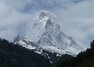
But the idea of seeing Matterhorn does not die hard, so when the next morning dawned with the cloud ceiling just a bit higher, we made a break for it.  We rode our unloaded bikes up the canyon to the view spot of the previous afternoon.  And we watched and took photos and had our photo taken in front of that iconic peak.  And even though the sun did not shine, all was forgiven.
Our first view of the Matterhorn!

Awesome!

Happy to be here!

Sunday, May 17, 2015

Ruffieux, France: ViaRhôna and Beyond

The ViaRhôna is a bike route along the Rhône river, going for 815 kilometers from the Mediterranean Sea to Geneva, Switzerland.  We joined it at the town of Veviers, north of Orange. And we were not alone.  France has four holidays in the month of May, and a good number of citizens decided to spend their vacation following the section we were on.  We were going north, and most everyone else seemed to be going south.  I am sure that is because the mistral winds blow generally from the north, but for a couple of days we had an anti-mistral tailwind while those poor folks were bearing down to make progress.  Initially we would say a hearty “bonjour” as we passed, but there were so many it became a “jour” and by the end of the day it was just a nod .
View from one of our many bridge crossings of the mighty Rhône.

More two-wheeled travelers.
Some sections of the route are newly developed with nice shiny signs detailing the  history of the local area and benches every five kilometers.  Other sections are along minor roads.  But there are directional signs on every intersection pointing the way.  Except for an older stretch of several kilometers that was slow going due to tree roots distorting the path surface, it was easy to follow and hardly a hill.
Pont de Rochemaure in 2015

Pont de Rochemaure in the19th century

The closest I have ever been to a nuclear power plant...just a hop over the fence.

Terraced vineyards across the river in Touron sur Rhône.
Campgrounds along the route are tuned to the needs of cyclists.  In the campground at Touron sur Rhône the proprietress placed us in a shaded lawn not far away from the “sanitaries” (toilets and showers).  And, she added in accented English, if we want a table and chair, there is a blue set around the corner, and “it is possible” to carry it to our campsite.  Campgrounds in France are inexpensive, 10 to 15 euros a night, but a table to eat on is a rare thing.  And it was the beginning of a trend for the next four campsites.  Sweet!
Our little blue table and chairs!
Another campground in Condrieu had a dedicated area with a canopy and picnic tables at each site.  When we arrived it was empty, and there was some wishful thinking that we might have it to ourselves.  We went off to shower, and by the time we returned to our campsite the whole scene had changed.  There were kids on mini-bikes everywhere, five family tents were set up, and the one little girl making laps had a clown horn that she honked, giving the whole place a circus feel.  Another guy had just arrived with a formidable bike trailer for his gear and his spaniel and was setting up right next to us.  But they were good neighbors, and we still marvel how the families took it all in stride when it started to rain heavily after dinner.  They all just sat under the canopy and talked and joked and made the best of it.  French parents are so mellow.  And our dog-loving neighbor spoke good English, and when we discovered the seam tape on our tent was leaking, he wrote out how to ask for “seam sealer” in French.
The Temple d'Auguste et de Livie in Vienne is an island of antiquity in an otherwise ordinary town.
The section of the trail that we traveled from north of Orange to Vienne was largely industrial -- manufacturing plants, nuclear and hydroelectric power plants, but often there were cherry and fruit trees in between and vineyards on extremely steep and terraced slopes.  Other than being flat and mostly off the main roads, the route was a bit uninspiring.  We took a diagonal off the route to avoid Lyon -- we didn’t want to deal with the the traffic of France’s third largest city -- crossing a high plateau of wide open wheat fields.  We rejoined it at the Pont d'Évieu, and followed the route that was now going east for the next couple of days.  This section was very picturesque -- canyon walls of limestone, narrow gorges, high bridges.   And lots of French families enjoying the Via Rhona, just like us.  We even said “bonjour” to a few as we passed them by.
Acres and acres of wheat fields on the plateau southeast of Lyon.

The east-west section of the Rhône, a more scenic stretch of the river.

All is well when the sun shines.

Maybe John and I should get a tandem, or bike naked, or both.

The mountains are calling...we are heading to the Alps!

Translate

Categories

Copyright

All original text and photos are copyrighted Doris Reilly © 2006-2023. No part of the content or the blog may be reproduced without prior written permission.
Powered by Blogger.

Contact Form

Name

Email *

Message *