It was a hot ride from the agricultural wonderland of the Nelson area to the mountain town of St Arnaud. It was a Sunday morning, our most favorite day to ride -- no logging or milk trucks passing us on the road. But as morning turned to afternoon, it heated up to the high 90's. At the end of a particularly steep three kilometer-long hill, we were both so overheated we stood under the shade of a tree for a good half hour and let the breeze bring us down to normal operating temperature, taking off as many articles of clothing within decency.
St Arnaud is at the shore of the glacial-carved Lake Rotoiti, a tiny town with a population of 60, and we were told 30 of those are children. With just enough services for those seeking to explore the lake and surrounding high country by boat, ski, or foot -- a couple of backpacker hostels, gas staion, and over-priced groceries. I swear this is the last time I will pay $2.00 for a tiny container of yogurt.
For us, we were keen on doing a three day, two night loop through the
Nelson Lakes National Park. So it required another changeover from biking to hiking gear. Unfortunately, we did not have a kind local resident to house our bikes for us, so we committed to staying at one of the hostels when we returned from the hike in exchange for gear storage while on our tramp.
 |
| Gear preparation in the patio area of the Sabine-Travers Lodge. |
 |
| A calm morning on the south shore of Lake Rotoiti. |
Beech forest surrounds the lake, and our first day of hiking was a short jaunt to the north end of the lake under the canopy of the forest that shielded us from the hot sun. Compared to the international expressway of the Great Walks we have done so far, this region is less of a "must-do", so it was a peaceful if not solitary experience.
 |
| Path through the forest composed of a variety of beech trees -- red, black ,silver, and mountain beech. |
And the existence of
honeydew has been revealed to us. The beech scale, an insect that bores into the beech tree and consumes the sap, excretes a sweet substance that is important to the ecology of the forest as a food source for many animals. Black mold growing on the bark of the beech trees are also fueled by this sweet nectar, making the trees look as if they have been singed by fire.
 |
| Honeydew droplets at the end of thread-like filaments. |
Our second day began to climb out of the forest to above treeline. We hiked up a canyon carved by the swiftly-flowing Hukere stream. As the canyon narrowed, the walls around us became steeper, and many downed trees due to windfall and avalanches required crawling on all fours to get by.
 |
| Water cascades from some source high above the canyon. |
 |
| We finally get above treeline, with a clear view of the ridge that still needed to be scaled before us. |
 |
| Bridges often seem to be in places where they are most needed. |
After about five hours of upward progress we faced a final push over essentially a goat track over scree. Good thing my husband has the patience of a saint, since I was an unhappy and fatigued tramper at this point.
 |
| View looking down to where we began, with still some uphill to go. |
 |
| Mountain Buttercup |
Once over the ridge, we were within spitting range of Angelus Hut, our destination. A long-time hut location, the actual building was totally rebuilt in the past year. A stunning setting.
 |
| The only location better than the hut was where we set up our tent. |
 |
| The hut is open to all year, and a wood-burning stove with racks to dry clothes must be especially appreciated for winter ski tourers. |
This tramp was a loop, and our return was along Roberts Ridge Route back down to the shore of Lake Rotoiti.
 |
| Before we could descend, we had to climb out of the lake basin where Angelus Hut is located. |
 |
| An alpine plant called appropriately Vegetable Sheep. |
 |
| The route goes across a bit before it goes down. |
 |
| Distant peaks and tarn viewed from the ridge. |
 |
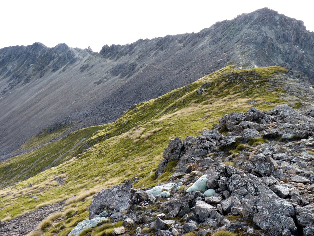
| A rocky section seemingly devoid of plants. |
 |
| As we drop the ridge becomes more rounded and covered with tussock. |
 |
| It seemed like most of the elevation was lost in the last couple of kilometers, as the trail wiggled down the scar of a landslide back to our starting point at Lake Rotoiti. |


1 comments:
Feels like I was riding along on top of your backpack!
Post a Comment