Monday, December 27, 2010

Warrington, NZ: Coastal Views

The last stretch of coast before reaching the city of Dunedin was traveled under gray skies, which seem to appear all too predictably after a day of fine weather.  A slight detour was made to Shag Point -- named not after any of these definitions, except for the one of the bird of the cormorant family.

Gray skies and gray-blue water offer only little contrast to the rugged brown rocks of Shag Point

Fur seals at Shag Point -- once hunted almost to extinction in New Zealand, now fish at night and sleep during the day.

No shags spotted, but plenty of gulls.
Staying off the main highway sometimes has it price.  In exchange for next to no traffic, there are some significant hills with killer grades.  Two big ones on the way to Dunedin were labeled with signs as scenic cycle routes.  Scenic, yes, but a cycle route only because bicycles were not allowed on the new highway, the one with wide shoulders and an even pitch, that leads into the city.

Looking north from the heights of Seacliff to the arcs of the bays near Karitane.

Our first view of Otago Harbour and the Otagop Peninsula from the summit near Mt. Cargill.

Almost there -- pondering our final descent into the city.
And then there is Baldwin St. in the suburbs on the fringes of the city.  It is claimed to be the "World's Steepest Street".  John cycled to the base of it to get a close up view, and got some of the bystanders excited that he would make an ascent with fully loaded panniers.

I overheard one conversation between a tourist and a local that lived on the street.  Obviously he wanted to drive his rental car up the hill, but was a bit concerned it would make it.  He asked several times -- can he do it?  The local replied, sure, a car can make.  But just don't take one of those rental campervan.  Makes me think it has been attempted, yet not achieved...now that would have been something to see.

Sightseers cheering John on in his aborted attempt on the World's Steepest Street

.

Saturday, December 25, 2010

Hampden, NZ: Christmas Balls

Christmas Day was a day of fine weather, and our gift was a tailwind pushing us down the coast in the quiet of the early morning, while the rest of the world was home opening their presents.

South of Oamaru, the coast was sparsely developed and dominated by tussock.
In the small town of Hampden, there is not much more than a fish and chips shop and a convenience store.  And a quiet little campground steps from the beach.  It was recently purchased by a young Swiss couple who are doing renovations, but still retaining the family feel of the place.  We walked down the beach a couple of kilometers to visit some famous residents -- the Moeraki Boulders.

As we walked along the sand, the rocks became gradually bigger and more spherical, dislodged from the horizontal beds on the cliff above.

Some of the boulders reveal their core when rolled and cracked in the surf.

I am only in the picture for scale.

Some of these concretions have a web of calcite veins surrounding and bisecting them.

Some of the giant cue balls in the area where most visitors can access the beach from a nearby car park.

The boulders are best viewed two hours before and after low tide.

As boulders get claimed by the sea, others emerge from the cliff.

.

Friday, December 24, 2010

Oamaru, NZ: Of Buildings, Bread, and Birds

We saw the Pacific from the eastern shore of the South Island for the first time in the town of Oamaru.  We exited from Central Otago for a singular purpose -- to see penguins, little blue ones and ones with yellow eyes.  We came for the birds, but we discovered a few other delights, too.

The railway station on a breezy and billowing Christmas Eve, following a morning rain that caught us and everyone else by surprise.
On our way through the countryside into town, where the road gradually descends through valleys between tilted beds of sandstone and limestone, there was an active quarry chipping out blocks of light tan limestone.  Had we known that so many historic buildings of Oamaru's prosperous past were constructed of this quarry's stone, we would have slowed down.

Pillars of the National Bank building in the heart of the Historical Precinct.
Christmas Eve was spent wandering around town and looking at all these wonderful buildings.  We learned of a bakery that sells bread baked in the traditional European style, so first thing in the morning we walked in the rain to find the shop in the old warehouse district.  Upon arrival, it was all shuttered up.  But then a small window opened in the large wooden door, and the head of a cheery woman popped out -- they did not open until 10:00 am, but if we wanted bread, she would let us in.  Dripping wet, we stood in the shop and had to decide between rye sourdough and Pain au Levain, and through a large window into the kitchen the baker was putting the last touches on several dozen mini-mince pies for Christmas.

The street closest to the waterfront that was formerly the location of warehouses and manufacturing.  Now it looks like an alley from the Old Country, and houses a little shop selling the best sourdough bread around.
Later, it was off to the Whitestone Cheese Factory, where Christmas Eve was celebrated with a platter of six artisan cheeses with fruit and bread from that very bakery.  The name of the company reflects the importance of the quarried stone, and the cheeses were named for places in the region.  We left with a bag of saturated fat delights for later -- Totara Tasty Chedar and Dansey's Pass goats milk cheese.

The main attraction, however, took place late in the day.  Yellow-eyed penguins are the rarest of all penguin species, and breeds only on the southern coast of New Zealand and its outlying islands.  They nest on the shore in the shrubby vegetation, and the parents take turns guarding and feeding the chicks.  And the changing of the guard happens twice a day, in the dim light of dawn and twilight. And twilight happens at about 9pm at this southern latitude.

It required a 5 kilometer bike ride over hills to get to the viewing spot, so we set out early enough to have picnic dinner while watching for penguins.

No chance getting lost on the way!
The penguins are very sensitive to potential danger, so viewing must be done so that they are not disturbed.  The Department of Conversation has constructed structures and viewpoints high on the cliffs above the beach where the penguins nest.

We munched on very good cheese and bread while watching for penguins in the fading light.  Our mates in the shelter were from the State of Washington...small world!

Zoomed in as far as possible, we captured this image of one of the four shy penguins that made an appearance that evening.  Note the band on his right flipper.
There are also Little Blue Penguins that also do a daily dance.  We cycled to various vantage points in the fading light where they are reported to frequent, but with no success.

Nightfall forced us home before our bikes turned into pumpkins.

Wednesday, December 22, 2010

Central Otago, NZ: A Gravel Trail Tour

It is a fact -- we are not the most spontaneous of people.  We have a route, we plan our meals, and we know which campgrounds are on the way.  So when John says "I have a wild hair...", I know this cruise ship of a journey is going to make a quick change in course.  And I get all fluttery excited.

When reached the town of Wanaka after crossing from the remoteness of the West Coast, it was filled with advertising and camper vans and tourists lying in the sun on the lakeshore.  The weather forecast was not looking good for the next week, and our plan was to head to Queenstown for some tramping in the mountains.  But stories of how busy it gets there over Christmas and the prospect of sitting out weather in an expensive town was not attractive. So we headed east.

Central Otago is the region east of the Southern Alps, in the rain shadow of those tall mountains.  It is open, dry, and warm.  And making a large arc is the Central Otago Rail Trail, a former railway that has been converted to a walking and bicycle trail.  The route goes through towns and intersects the paved road on occasion, but the gravel route generally passes through sparsely populated farmland and wide open country with big skies that made us feel like we were home.

Our first day was filled with sun and puffy clouds.

The rivers in this dry region flow slowly, especially with the recent drought.

The rails have been removed along the route, and bridges planked for smooth crossings.

Former station locations have been converted to information shelters, a true 'outdoor museum".

Passing through cuts made in the rock, necessary to maintain an gentle grade, gave us the sense that those old steam engines weren't all that big.

We spent two nights at the Omakau Recreation Reserve, an excellent domain facility.  There we met George, a fellow bike tourist, and we spent the time sharing experiences and the Sunday paper.

Fireplaces are all that remain from the railway construction camp from the early 1900's.

Entering one of four tunnels along the route.

The bridges are most impressive because of the hand-hewn rock.

Big sky country, Kiwi style.

Near the high point on the trail, the Wedderburn station was the smallest staffed station at the time it was operating.  It wasn't more than a big lean-to.

Our last night on the trail was a stealth camp next to a creek, providing shade and coolness on a hot day.  Please forgive us for violating the 100-foot rule.

Laundry hanging at our creekside campsite.

We did not complete the entire length of the 150 kilometer trail, but rather exited at Ranfurly to take a more direct route to the coast over Dansey's Pass. We knew at least it was a gravel road in good condition, and there were no great negative reactions when we told locals of our intent, so that was enough to satisfy the planning need within us.

But what we could not control was the wind -- gusty and strong that whipped up dust and nearly knocked us off our bikes.  We met two other German cyclists coming down, and they were nearly in shock from the struggle.  We only had to fight it for about 15 kilometers, and we camped in a dense pine forest near the base of the pass.  Our campsite was so protected we felt barely a breeze, even though we heard it swishing thorough the treetops above us throughout the night.

Approaching the pass outside of the cute town of Naseby.

Miles from nowhere, you can still get most anything you need.

Our wooded campsite, in a forest of pines planted by the miners that worked in this area over a century ago.

The next morning we set out for the pass after morning rain shower.  The skies cleared, but the wind persisted.  Fortunately, it was to our backs, so at times it felt like a gentle hand was pushing us when we needed it the most.

A steady and even grade to the pass.

Tussocky slopes looking southwest from Dansey's Pass, with a view of the ocean in the distance.
The downhill was fine until we reached a section of road that was freshly graded.  No longer packed by passing cars, the road surface was difficult to navigate.  At one point I got going a bit too fast, and braking just caused my bike to fishtail.  Next thing I knew, I did a slide into homebase, panniers strewn on the road, but with only a scraped and bleeding elbow as a result.  We proceeded a bit more carefully after that, until reaching the flat and paved road in the valley.

 Looking back from where we came during our cautious descent, despite the approaching threat of rain.

.

Tuesday, December 14, 2010

Haast, NZ: The West Coast Hustle

Lingering on the West Coast seemed to us like living on borrowed time.  Rain was inevitable, just like the rising of the sun and moon each day. When the rain finally eased in Fox Glacier, and the forecast was for a couple of fine days, we saw it as an opportunity to finish off this side of the island.

We crossed rivers swollen from the recent rainstorms.  The peaks shyly appeared as the clouds moved about.

We started our cycling day in a strong drizzle that evolved into something resembling rain. But soon it ended, the clouds parted, and blue skies and a favorable wind greeted us when we emerged from the forested inland to the coastline.

Strong storms have piled driftwood on the sand at Bruce Bay.

We were both "on" this day -- and early start, a slight downhill, and wind in our favor had us at 60 kilometers by lunchtime. And the prospect of smoked salmon may also had some influence. Out here, in this stretch of 100 kilometers between services, is a salmon farm, where wonderful things with pink fish are made. And there was a cafe, and we celebrated my birthday eve with a lunch of great density. Ordinarily, high-fat foods are verboten for me. But when asked what to have on my smoked salmon panini, avocado and cheese were chosen to feed that deep hunger that distance cycling brings on.

Ponds at South Westland Salmon Farm near Lake Paringa.
Full bellies and a couple cups of strong New Zealand brewed coffee pushed us over our normal, comfortable 80 kilometer day. A series of steep, curving roads to get over the coastal headlands didn't even seem to slow us down.

View from Knight's Point lookout.  There were no roads to this coastline when it was settled in the 19th century, and cattle were brought in by boat and had to swim ashore, not far from this location.


The final stretch into Haast -- flat road and deep forest on the edge of the coast.
We pulled into the village of Haast by 6:00 pm, 125 kilometers from where we started that day.  A personal record for both of us for distance with fully loaded panniers. 

But the challenge was not over, since it was another day of cycling to get over Haast Pass to get off the Westland side to the rain shadow of the Otago side.  Not a far distance, but a 564 meter ascent from near sea level. No rest for the weary, or for a girl on her birthday.

The day was brilliant from the start -- blue skies, gentle breezes.  And the road was a moderate grade with gentle curves as it headed towards the pass.  A three kilometer stretch of thigh-busting road after the Gates of Haast made me long to be in my forties again, like I was just the day before.  But all good things come to those who persevere, and it was a thrill to reach the pass and the mid-century mark on the same day.

The Haast River meandering its way to the sea.

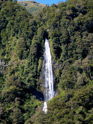
Spectacular waterfalls still flowed from the recent rains.,

The canyon narrows and the peaks get higher as we work our way towards Haast Pass.

The Gates of Haast, the gorge where the Haast River flows down the steepest gradient along its path. 

The birthday girl chugging up the grade.

The Haast River, almost a creek near its headwaters.

Happy Birthday!

Translate

Categories

Copyright

All original text and photos are copyrighted Doris Reilly © 2006-2023. No part of the content or the blog may be reproduced without prior written permission.
Powered by Blogger.

Contact Form

Name

Email *

Message *