Tuesday, September 26, 2006

Wanderings in the Eastern Sierra


With about a week and a half to squander before our move to our new place in June Lake, we ended up wandering in the Eastern Sierra. Mom and Dad were heading south, and we were able to meet up for a night in the Oh! Ridge Campground in June Lake. The weather was cloudy and cold, so we spent a morning walking the neighborhood around June Lake so we all could be come familiar with our future surroundings. Mom and Dad proceeded south to warmer climes outside of Lone Pine at one of our favorite campgrounds at Tuttle Creek. We stayed up north, hoping for clearer weather for some hikes.

Mornings are consistently cold this time of year, often in the low 30’s. This dictates our morning routine. The sun does not break over the horizon until about 7 am, so we put on all our layers before emerging from the tent. John starts the stove to boil water for tea, and we take down the tent before breakfast. By the time we eat and pack the remaining gear into the truck, we are chilled. We start up the truck, pile in, and blast the heater on the way to the trailhead. Upon arrival, we put on our boots and change into our hiking shorts. It is a bit chilly for the first mile of hiking, so we move briskly.

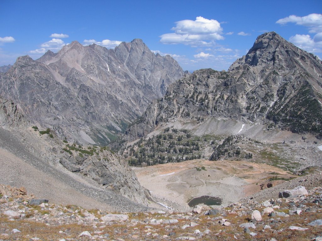
We had some notable hikes. One was up the Sierra Crest south of Mammoth Lakes. This spine is the divide between the watersheds where water flows west to the Pacific, or east into Owen’s Valley. It is also an important physiographic feature – the moisture-laden clouds of winter storms draft up from the west and hit the crest, releasing moisture in the form of snow. Mammoth Mountain, in the heart of the ski area and on the Crest, acts as a barrier and receives much more snow than locations just a couple of miles to the east which lie in the shadow of the mountain range. The top photo is a view looking north from the Crest – Lake Mary and Twin Lakes are in the foreground, the town of Mammoth Lakes beyond them, and the prominent bare mountain to the left is Mammoth Mountain.

Another day was spent hiking up McGee Creek Canyon to Steelhead Lake. Lunch was consumed on the shore of the lake, and jumping fish frequently broke the surface of the water. The water was so clear we could see them swimming just offshore. It was the middle of the week, and no one was there to try hook them – we don’t fish, so these trout were safe.

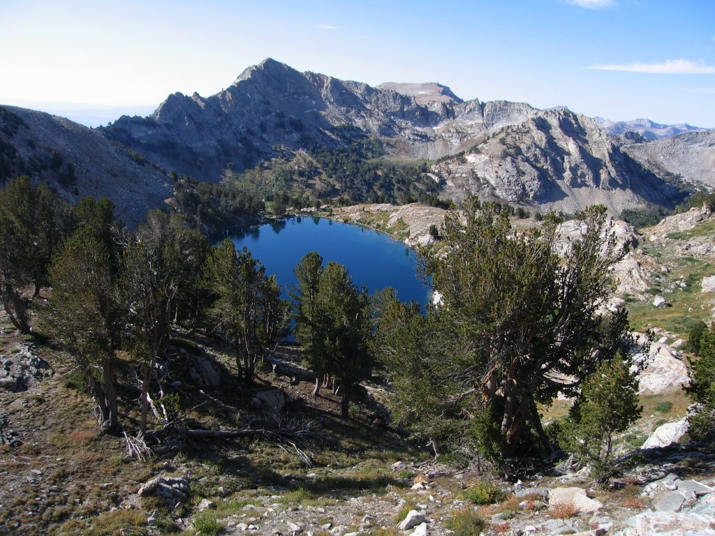
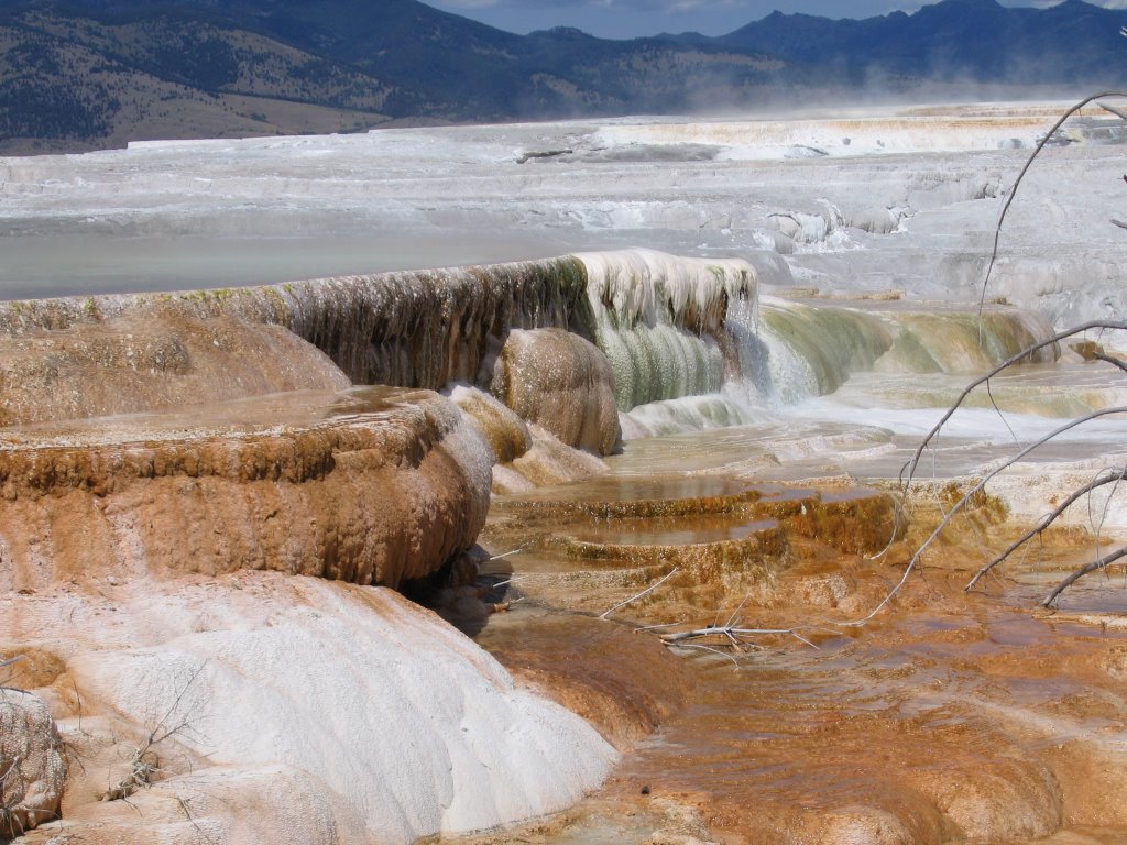
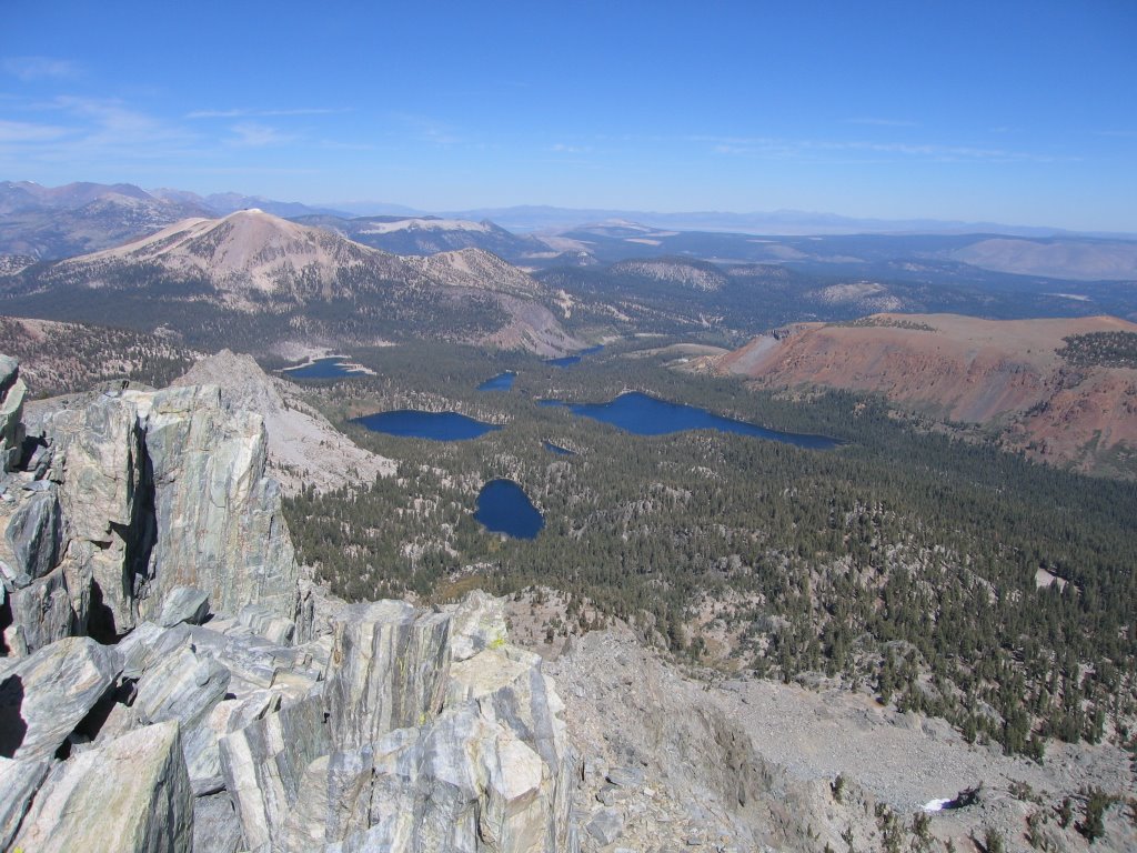
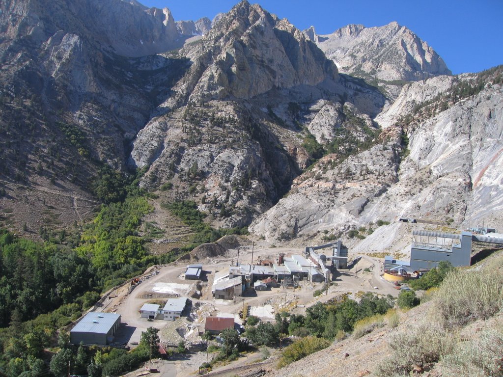
A hike up Pine Creek Canyon just north of Bishop was a spectacular day. This canyon is the location of historic tungsten mining operations. Although not currently active, the facilities look like they could be called into service at anytime. The second photo shows the mill operations near the trailhead. We followed the path of the road leading to the ore deposits. This road is no longer maintained, but easy to follow by hiking. It was a steady grade, passing through the zone of contact metamorphism that created the skarn deposits that are so rich in tungsten. The colors of the rocks in the canyon were marbled and deeply contrasted between the gray of the intrusives and the red of the country rock. The road eventually ends at Morgan Pass, but we stopped a couple of miles short of that to eat lunch on the shore of Lower Morgan Lake. The third photo is a view of this lake.

After a dip in Keough Hot Springs , we too ended up at Tuttle Creek for yet another reunion with Mom and Dad. Strong winds due to a Santa Ana condition kept us near camp for a much-needed day of rest.

Tuesday, September 19, 2006

Gimme Shelter


Once we started on our journey south, we covered the distance in five days what took us nearly 3 months to travel on our way north. After leaving Mom and Dad in the chilly high-20’s morning in Jackson, Wyoming, we pointed the truck onto the interstate and pulled off a 300 mile day. One long stop in Twin Falls for grocery shopping, and we arrived at Bruneau Dunes State Park in south-central Idaho. It was the Sunday of Labor Day weekend, so we were lucky to find a slot late in the afternoon. The next morning we did a short walk to the edge of the dunes (top photo), windblown remnants of Lake Bonneville that once covered a huge area in the Plesitocene era.

Back on the road, we dropped into Elko, Nevada and beyond to the base of the Ruby Mountains. The campground was full, so we found a dispersed campsite within Lamoille Canyon to pitch the tent and make dinner (second photo). The next day we did a day hike to Liberty pass, with excellent views south to Liberty Lake (third photo). Back to the truck by noon, we drove the afternoon through the desert along the Humboldt River, previously the route of the pioneers heading to California. Late in the afternoon we found a campsite in the National Forest north of Winnemucca. Or fourth day of travel brought us into Washoe Lake, within striking distance of Mammoth Lakes.

The rush was to get to Mammoth by Thursday morning. Our mission was to find a place to rent for the winter. We had been monitoring the online classified ads in the weekly local paper for the past month. We wanted to be there when the newest issue hit the stands so we could be the first to call on the new ads. Our calculating approach paid off – we found a small cabin in the woods for rent in Old Mammoth. From the driveway we called the landlord, who faxed us an application by 9:30 am – we faxed the completed form back to him by 10:30 am. We both were excited with the possibility of finding a place so quickly.

We continued looking at other places while waiting for word on the cabin – everything from high-priced furnished condos in the $2K/month range, to multi-unit apartments. An unadvertised unit above a plumbing shop got our attention from a “For Rent” sign on the street. We left an application there, too. We ventured over June Lake to touch bases with our Ski Patrol friends. A tip to talk to a local business owner proved our timing was right on. She had a two-bedroom unit coming available. We talked awhile; we filled out an application, and made plans to see the unit in a couple days once she contacted the current tenant.

So the waiting began – we decided to do a day hike up Rush Creek out of June Lake. We took the phone with us just in case we got a return call. On the way up the Mammoth cabin landlord called – we made plans to meet him later that afternoon. On the way down we got a call from the June Lake landlord. She said if we could get there before 2 pm we could see the unit. It was 1:00 and we were still a mile and a half from the trailhead. We said we would try – we were literally running down the trail. We were there by 1:45 pm, but the current tenant had already left. We peeked into the window, however, and saw the interior – the unit was less than 10 years old, with double-paned windows, a dishwasher, and forced-air furnace with programmable thermostat. It was perfect.

As it turned out, we had the option of picking any of the three units we applied for – we were the perfect prospective tenants – no pets, non-smokers, and not youngsters in their twenties. Any of the landlords would have loved to rent to us. We opted for the June Lake unit – it was the cheapest, largest, and did not require a year lease (our preference, since we want to travel again next summer and not pay rent, too). We left the area to head to Orange County, where I had some work to do for my former employer, after investing only three days in finding a place to rent. We entered into this search with the fear it could take three weeks.

A week in Southern California is nothing special to blog about. Other than the enjoyment of seeing our good friends at OCWD, dealing with tailgating commuters, traffic, and noise left us wondering how we ever survived down there, and made us even more secure in our retirement decisions. We picked up our Honda, stored for the summer in Hemet, to put in storage in Bishop to simplify our move in October. John and I drove in separate cars north, each listening to our respective music choices at full volume. We camped at Fossil Falls, south of Lone Pine, and enjoyed the solitude and quiet of Owen’s Valley in the morning light (last photo).

Yellowstone Videos

due to technical difficulties, I was unable to upload three videos with my last post about Yellowstone. I have since overcome those difficulties, and the videos are up and available for viewing from the post titled "Return to Yellowstone".

Remember, to view these videos you will need to down load the Adobe Flash Player.

Thursday, September 7, 2006

Mom's Final Words


Can you imagine being married for 50 years? This happened to Ali and I on August 31st. Our two “super hikers” invited us to an authentic Wyoming Cowboy BBQ dinner at Moose in the Jackson Hole. Wooden tables and benches were arranged outdoors with the Grand Teton Mountain Range soaring towards the sky as backdrop. There was a huge teepee erected on the grounds and beside it an old pioneer wagon decorated with colorful flowers. We enjoyed the atmosphere and pigged out accordingly.

The celebration occurred a few days ahead due to another planned hike the next day. Our help was needed to shuffle the hikers to their trailhead starting below the Teton Pass. We two oldies strapped on the backpacks for a try and with wobbly knees took a few steps. We decided this was definitely not our cup of tea. We practiced saying "good bye" right there not knowing whether Doris and John would find the time to stay with us after conquering those spectacular peaks. They have to be back in California at a set date.

Dad and I found the ideal campsite on a lake in the Bridger-Teton National Forest and we decided to stay here over the Labor Day weekend. Late afternoon on Friday, August 31st, a red Toyota backed into our site and the joyous shouts of our voices greeted them: "The kids are here! The kids are here!" We received their congratulations - an embrace and kiss - due to us on this special day. We all agreed -- we have had a wonderful summer. One of the best for Dad and me, with lots of good memories to stuff into our almost overflowing memory bag.

Who would like to accept some advice on a good marriage? From the pinnacle of age and wisdom I dispense my recipe gladly:

"Have a strong mutual interest together and if there is a behavior by your spouse that irritates you, swallow in silence because it's always is a two-way street!”

It has been a great pleasure for me to talk to all you people floating out there in cyberspace.

Thanks for listening! Bye, bye from Mom Brukner

Posted using wi-fi provided by Mammoth Lakes Public Library, California

Teton Backside


Yellowstone National Park shares its southern boundary with Grand Teton National Park. Despite their close geographic proximity, the landscape could not be any different. Where Yellowstone is relatively flat with thermal features, Grand Teton is all about mountains. Rising to the west from the valley floor of Jackson Hole, the peaks stand like an impenetrable wall. Only the most skilled mountaineers can stand on the tops of the peaks, the most prominent being Mt. Moran (12,605') and the Grand Teton (13,370'). Most visitors choose to gaze at them in the morning light from the valley floor. For us, however, we had been anticipating all summer to do a multi-day hike along the Teton Crest Trail, which traverses 40 miles along the backside of the peaks.

The trail goes in a linear north-south direction. This required some logistical support from Mom and Dad. We would leave our truck at the northern trailhead, which would be our exit point. We would then load all four of us and our backpacks in Mom and Dad’s van, and drive south through Jackson and up Teton Pass to the southern trailhead. Dad was a bit hesitant about this scheme – besides the illegality of two unsecured passengers in the back, it required getting up before the sun to get an early start. We bribed them by going to dinner at Dornan’s Chuckwagon BBQ in Moose, Wyoming the night before. We ate outdoors on picnic tables with the enormity of the Tetons as a backdrop. Food was served from dutch ovens over hot coals – mashed red potatoes, beans, carrots, biscuits, and stew. All washed down with a cold draft beer. Another motive of this feast was to celebrate Mom and Dad’s 50th wedding anniversary on August 31.

Thunderstorms overnight soaked our tent, so the plans for an early start was somewhat thwarted. We spent an hour spreading wet nylon on the ground to dry in the parking lot as we readied our packs. We then piled in the van, and made the drive to the other trailhead. Teton Pass has grades of 10 percent in places, and the van labored slowly with the added weight of passengers and gear. We said our good-byes to my parents, and started hiking by 10:30 am.

The Teton Crest Trail follows the tilted sedimentary beds uplifted during the mountain building of the range. When you view the Tetons from the valley floor to the east you see only the granitic rocks underneath. We were on the gentler western slope, and the trail followed “benches” of the more resistant sedimentary layers. Much of the trail was at about 9,000 feet elevation, so the wildflowers were still plentiful and the meadows lush. The top photo is from the morning of our second day, looking down on Marion Lake with cliffs of limestone in the background.

Days 2 and 3 were long ones, 14 and 12 miles respectively. We crossed several passes, two of significance. The first was Hurricane Pass at the end of Day 2 – the view looking northeast from this pass is shown in the second photo. From here the backside of the trio of peaks – the Grand Teton, Middle Teton, and South Teton – are in full view. The glacier at this pass has also receded significantly – note the turquoise lake in the foreground, and the moraines left behind by the melting ice.

The second pass on Day 3 was Paintbrush Divide, the view from which is shown in the third photo. The wind was howling when we were there – gusts of probably 50 miles per hour exacerbated by a high-profile backpack kept me from walking a straight line. It was difficult to hold the camera still, but fortunately the pictures came out in focus. From this pass we could see Mt Moran, the massive peak on the left of the photo.

Our last day was just less than 5 miles, so we were out before noon. We were able to shower, do laundry, and check our email before reuniting with Mom and Dad for our final night of camping together. Mom and Dad will be taking a much more leisurely pace home. We have to break out of the “not-more-than-60-miles-per-day” philosophy we have lived all summer and drive south to look for winter housing in Mammoth and other commitments in Southern California. Our last night together was cold – it dropped to the high 20’s. Fall comes early in the north, so I suspect Mom and Dad will be accelerating to warmer latitudes soon, too.

Posted using wi-fi provided by Mammoth Lakes Public Library, California

Return to Yellowstone


If Yellowstone is not the most visited National Park in the United States, then it is near the top. We now understand why – it is a truly unique place. The sites in the park are dispersed enough to spread the visitors around, and the most popular sites, like Old Faithful, are well laid out for crowd management. It is a playground for geologists. Not only does it have steaming vents, mud pots, and geysers, it has rivers with waterfalls carving through the multi-hued volcanic rocks of an ancient caldera. We had seven days to explore the park, and managed to see most of easily accessible thermal features.

Rather than describe what we saw, I will instead share a few of our favorite images and movies. If you have not been there – GO! It is like no place else on Earth.

The photos, from top to bottom, are described below:
  • Top – Terraces in the Mammoth Hot Springs area,
  • Second -- Lower Falls of the Yellowstone River from Inspiration Point,
  • Third – Steam at the Grand Prismatic Spring in the Middle Geyser Basin,
  • Fourth – Elk grazing with Old Faithful and the Upper Geyser Basin in the background.

And here are a few 30-second videos, too

Posted using wi-fi provided by Mammoth Lakes Public Library, California

Translate

Categories

Copyright

All original text and photos are copyrighted Doris Reilly © 2006-2023. No part of the content or the blog may be reproduced without prior written permission.
Powered by Blogger.

Contact Form

Name

Email *

Message *