
Crossing Bridges

We are now a party of four. We have reunited with my parents outside of Marysville at the home of a longtime family friend. Gathered were about 40 friends and family of our hosts, Bob and Darlene. I have not seen some for probably 40 years, and among the other guests were friends who said things like “The last time I saw you, you were this tall!”, while stretching their hand out about 3 feet above the ground. The attendees stayed in motor homes and tents parked on the perfect green lawn that stretched like an apron from the barn-style house among the oak trees. There was a potluck at every lunch and dinner, spontaneous conversations, and lawn games to keep us occupied throughout the days. And to top off this food fest, we also had time to visit with my cousin in Yuba City with a bar-b-que at their home.
We left the Eden-like setting of our hosts on the Tuesday following Memorial Day to avoid traffic. Our pace is now a bit more relaxed – in the morning there is time to take a walk, cook some oatmeal for breakfast, pack our gear, and hit the road about 9 am. Distance traveled is generally not more than 60 miles a day, with frequent stops at fruit stands and sites of historical interest.
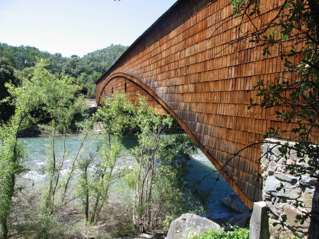
On this, our first day of travel together, we stopped at the Bridgeport Covered Bridge, located on Highway 20 and crossing the South Yuba River. It is claimed to be the longest covered bridge in the country – well, make that the longest single-span wooden truss covered bridge. Built in 1862 and restored in 1971, it is a solid 229 feet long from portal to portal. The North Blenheim Bridge in New York is second at 228, although the if you measure the clear span between bridge abutments is 210 feet for the New York bridge compared to 208 for the Bridgeport Bridge. I guess it depends on how you measure it. One of only nine covered bridges in California, it is constructed from Douglas Fir milled from the nearby forests.
Quoting from the information pamphlet posted at the bridge, the answer to the question “Why was the bridge built here, in the middle of nowhere?” is as follows:
“The Bridgeport covered bridge was part of the fourteen-mile long Virginia Turnpike. The turnpike was part of the Hennes Pass Route, a freight wagon road between Marysville and Virginia City, Nevada, during the Comstock silver rush. Tolls were charged for passage on the roads and bridges along the route.
Turnpike companies were authorized by the state in 1853 to build and maintain roads and bridges as business ventures. When the Central Pacific portion of the transcontinental railroad was completed in 1869, it led to the eventual demise of turnpike roads in the Sierra. The Virginia Turnpike route was long used for driving livestock to and from higher and lower elevations, and as a route to the northern mining towns, such as North San Juan.”
The only traffic it allows now is people walking across, and vehicles now cross the river a quarter mile upstream across a modern concrete bridge. Not nearly as romantic or picturesque.
0 comments:
Post a Comment